


 Email this Article
 Print
Print Download (PDF)
Abstract 
Ruoergai Plateau (>3000 m in altitude) holds the largest peatland in Chaina, although the vegetation has been deteriorated mostly by cattle grazing. To determine how plant zonation patterns differ between sites with different topography in the alpine grassy marshland, plant establishment height above the water surface was measured for each species in two sites, Ouhailao and Kaharqiao, using a point transect method. In both sites, hummocks were well-developed, but their sizes were larger in Kaharqiao. Graminoids, primarily Kobresia tibetica and Blysmus sinocompressus, dominated in both the sites, while forbs were sparse. Distinct plant zonation patterns were observed. Patterns of hollow-hummock variation develop in both sites, although the ranks of species establishment height differed. Graminoid species at the two sites displayed markedly different ranges and ranks of establishment heights, and the individuals rarely were associated closely with other species. In contrast, little change of the extent of establishment heights was observed for forbs such as Potentilla anserina and Caltha scapiosa, which seemed not to exclude the cohabitants. The different responses to microtopography between forbs and graminoids resulted in different plant zonation patterns between sites. The differences of plant plasticity between graminoids and forbs seem to have a key role on the zonation patterns.
Key words: China; Grassy marshland, Hummock, Life form, Microtopography, Ruoergai, Water depth
Introduction
Relationships between topography and plant establishment pattern in wetlands have been examined via various ways, although the relationship has been still controversial (Keddy 2000). In particular, water depth, which is related to topography, strongly affects species establishment patterns in wetlands (Tsuyuzaki 1997, Bragazza & Gerdol 2002). In addition, the response and interaction of wetland species vary with environmental fluctuations (Keddy 2000; Miller & Zedler 2003).
Although the Ruoergai marshland, north Sichuan Province, China, is the largest peatland of the country, few studies of vegetation development patterns have been reported with reference to topography and water depth. In this area, I suspected that zonal distribution occurred, but that the patterns would differ among sites with different topography because of the differences of plant response to the topography. In parts of Ruoergai marshland, hummocks are well-developed (Nagasawa et al. 1994).
The biodiversity of this bwetland is now threatened due mostly to cattle grazing and, and may be altered by global warming (Miehe & Miehe 2000). Furtheremore, the privatization of the wetland has recently allowed because of the national policy of China, and grazing and the other human activities have been allocated. (Zhaoli & Ning 2005). To clarify the changes of zonal distribution patterns, I surveyed both species and microtopography patterns, based on plant establishment heights above the water surface. Major questions posed in this study are: 1) is zonal distribution observed? 2) does zonation differ among habitats with different microtopography? and 3) if this difference is observed, how do the species respond to the habitat differences? Materials and Methods
Two study sites, Ouhailao (3,570 m in altitude) and Kaharqiao (3,450 m), were selected for study in Ruoergai marshland in Sichuan Province, central China (32o20'-34o10'N, 102o15'-103o50'E) (Fig. 1). About 2,696 km2 of this marshland is covered with peat. The Ruoergai marshland is surrounded by mountains, some of which are over 4,000 m in height. Mean annual temperature is 0.6-1.5oC, and annual precipitation is 560-860 mm (Zhaoli & Wu 2005). Peat thickness is more than 1 m in Ouhailao and varies from 65 cm to more than 150 cm in Kaharqiao, with a maximum depth of 4 m (Kamiya et al. 1990). In both areas, hummocks are well-developed (Nagasawa et al. 1994). In this wetland, there is conspicuous yak-grazing (Tsuyuzaki & Tsujii 1990). The other major livestock are horses and sheep.
Using a point transect method (McMahon 1995), five 20-m line transects were sampled across the hummocks in each study site and 1,005 points were marked at 10-cm intervals. At each sample point, I recorded the species present and the distance between the establishment point was above the water level at the time of establishment. Negative values indicate that establishment was below the current water level. When the water depth was lower than the ground surface, I determined the depth by soil excavations. In addition, a 2-m in length within a 20-m transect was sketched on a section paper in Ouhailao and Kaharqiao, respectively, to grasp a representative plant establishment pattern.
The mean, standard deviation, and variance of the establishment height from the water surface were calculated for each species in each site. An F-test was performed on the comparison of variance, i.e., the extent of establishment heights, on the species observed in both sites (Zar 1999). To compare the difference of species ranks of establishment heights between two sites, Kendall's rank correlation test was conducted. 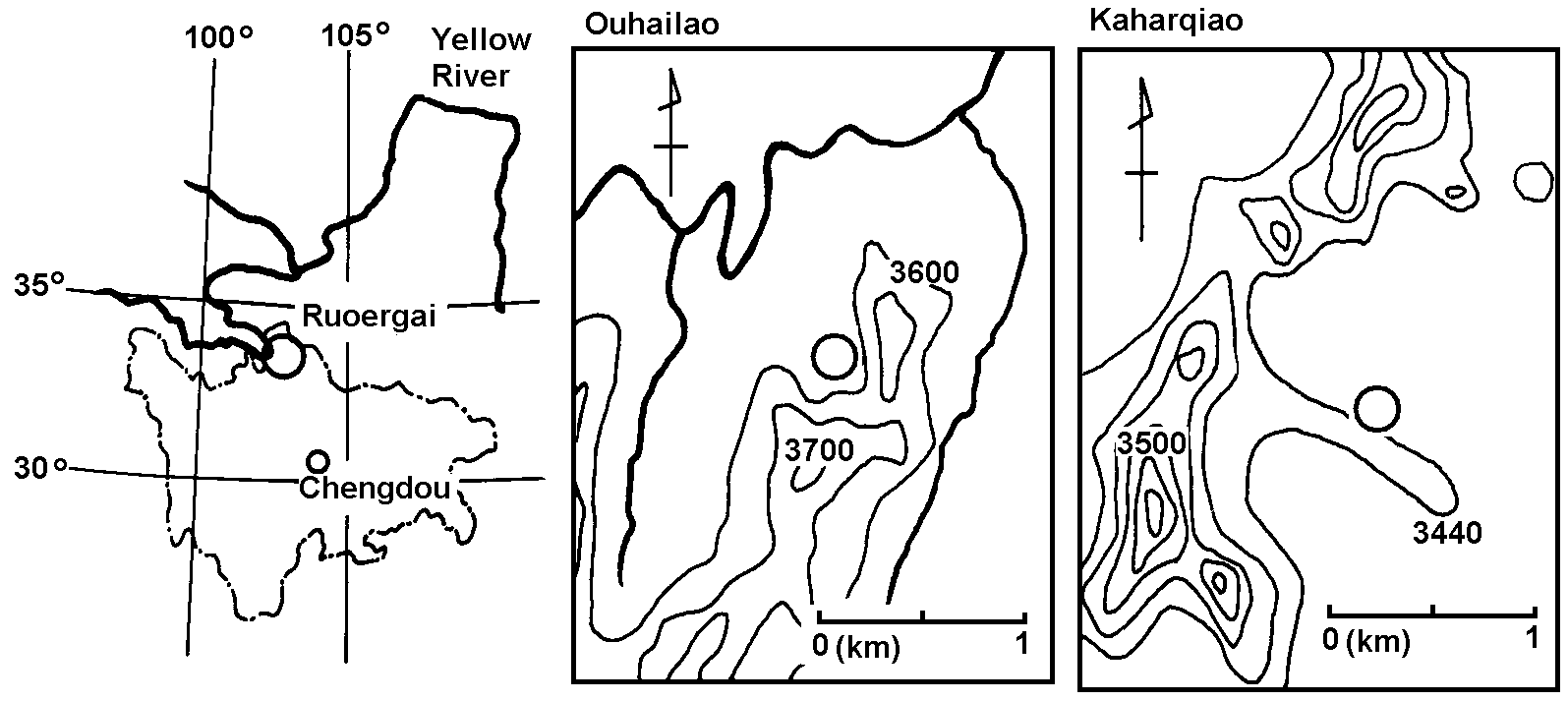
Figure 1: Study area. Left: Location of Ruoergai wetland in Shichuwan Province, China. Center: Location of study site on Ouhailao. Right: Location of study site on Kaharqiao. Open circles denote the locations of study sites.
Results
Topography
The heights of hummocks above the ground surface averaged 30 cm in Ouhailao and 50 cm in Kaharqiao. The maximum differences of plant establishment height in transects were 13.5 and 46.0 cm in Ouhailao and Kaharqiao, respectively. Therefore, topographic variation was greater in Kaharqiao than in Ouhailao. The widths of the upper parts of hummocks ranged from 20 cm to 60 cm in Ouhailao, while those in Kaharqiao were relatively large, i.e., 40-120 cm. The widths of hollows were also 30-100 cm, therefore, each line contains ca 20 hummocks. The water table was nearly at the bottom of the ground surface. Water depth ranged from -2.5 cm to +16.0 cm in Ouhailao and from +24.0 cm to +70.0 cm in Kaharqiao. The water table was essentially at the level of the hollow bottoms at the time of the survey at Ouhailao. At Kaharqiao, it was 20 cm below the surface of the hollow bottoms. Species patterns
Eleven species were recorded in Ouhailao and fourteen species were recorded in Kaharqiao. In total, 18 taxa, consisting of 12 forbs, and 6 graminoids, were recorded. Nine species occurred in both the sites (Table 1). Only 37.9% of the sample points hit plants at Ouhailao. Plant density was higher at Kaharqiao, where 67.3% of the sample points hit plants. Therefore, plant frequency at Ouhailao was about half that of Kaharqiao. Two sedge species Kobresia tibetica and Blysmus sinocompressus dominated both sites. A few species, e.g., Caltha scapiosa and Blysmus sinocompressus, established in the hollows. In contrast, there was little vegetation on the slopes of hummocks and in hollows at Kaharqiao. The forbs Cremanthodium pleurocaule and C. scapiosa were present on the slopes, although they were never dominant. Carex meyeriana and Potamogeton perfoliatus, which only were found in Kaharqiao, occurred in shallow sites, while Trollius ranuncloides established in deep sites.
Mean species establishment heights differ greatly between the species on each site (Table 1). Three species, Carex meyeriana, Potamogeton perfoliatus, and Carex sp., which appeared only in Kaharqiao, showed the lowest establishment heights, and Trollius ranuncloides showed the highest establishment height (Fig. 2). Therefore, there appears to be zonation and specialization with respect to establishment requirements at each site. 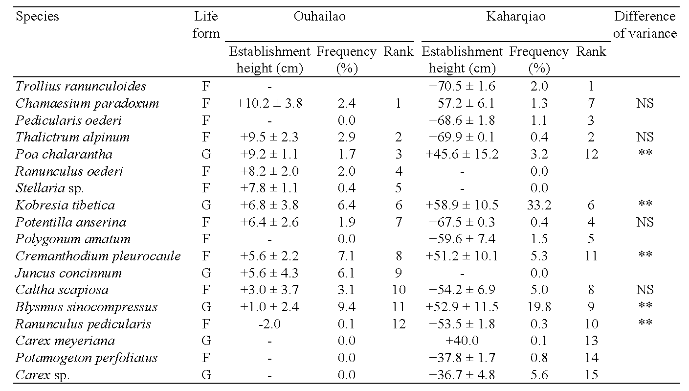
Table 1. Mean water depth of establishment height, frequency and elevation rank of each species. Each numeral shows mean establishment height above or below water surface with standard deviation. -: no individuals observed. Difference of variance between the species in Ouhailao and Kaharqiao is determined by F-test. **: significant at P<0.01. NS: non-significant. Kendall's rank correlation test confirmed that the rank between two sites was not significant. F indicates forbs and G indicates graminoids.
The establishment height of total species was ca 30 cm higher in Kaharqiao than in Ouhailao. However, water depth declined during the survey period, due to the lack of precipitation. Thus, the ranks of establishment height and the standard deviation of establishment height were used to compare species and habitat differences. The order of establishment heights differed significantly between the sites (Kendall's rank correlation, r = +0.278, non-significant), indicating that the zonal distribution patterns of species differed between the two sites. The extents of establishment height, expressed as variance, of three graminoids, Poa chalarantha, Kobresia tibetica and Blysmus sinocompressus, were significantly wider in Kaharqiao than in Ouhailao, while those of forbs except for Cremanthodium pleurocaule showed non-significant difference between the two sites (Table 1). When topography was diverse, graminoids could extend their range of establishment heights more than the forbs. There were 47 (12.3%) points on the lines that recorded more than one species in Ouhailao and 130 (19.2%) in Kaharqiao. Only a few graminoids co-occurred with any species in either sites (Table 2), while they often co-occurred with forbs. Forb species co-occurred with other forb species in Ouhailao, but co-occurred with graminoids in Kaharqiao. Although forbs had low cover and did not alter extent of their establishment heights, they co-occurred with the other species more than the graminoids.
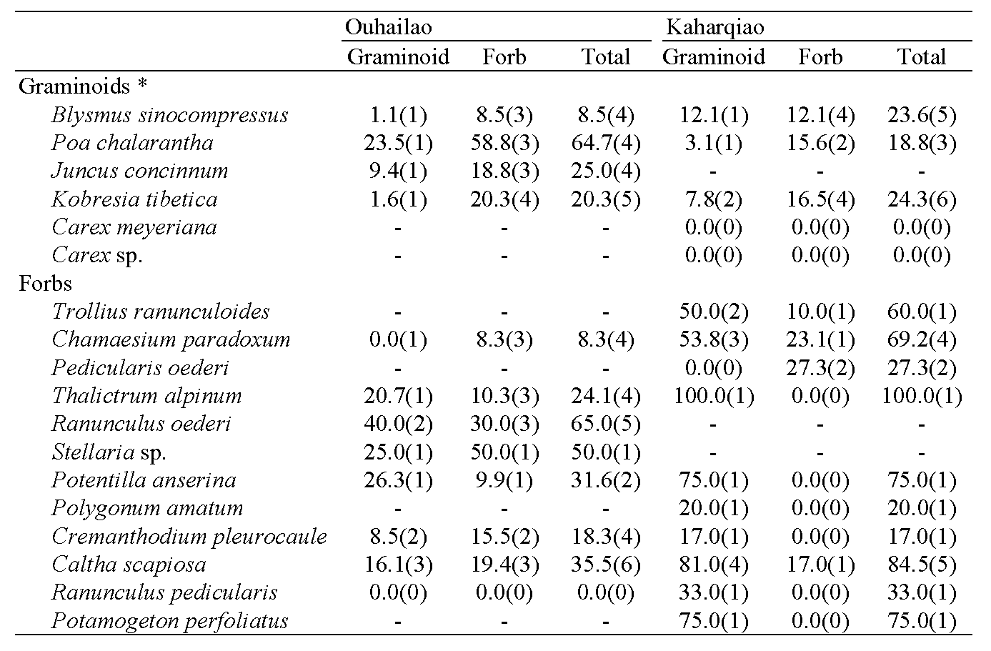
Table 2: Percent frequency of coexistent species in the points where any species were observed. In parentheses, the number of species which were recorded at the same point are given. -: no individuals observed. *: graminoids include sedges.
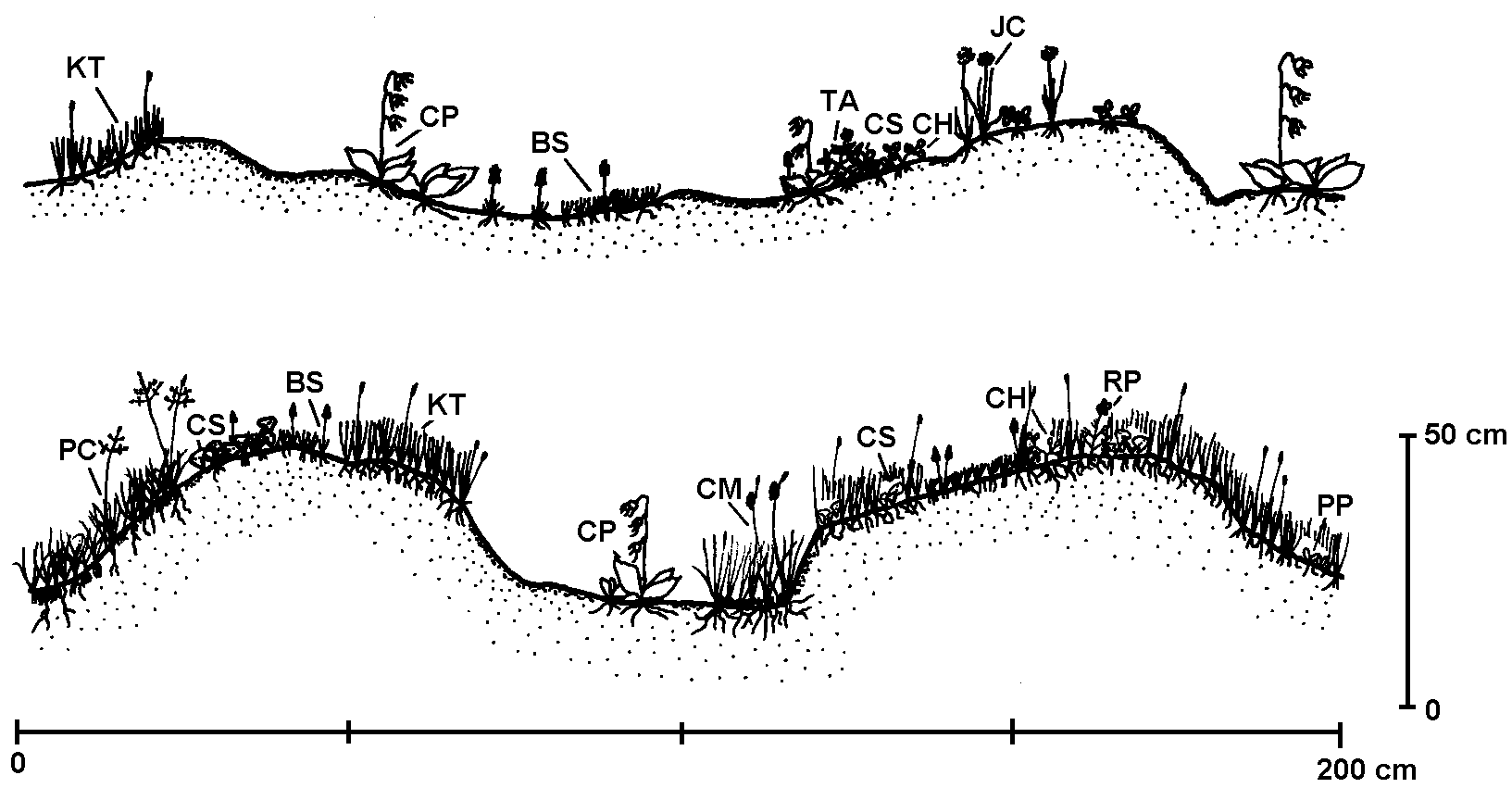
Figure 2: Schematic illustration of plant establishment patterns with reference to topography. Top: Microtopograhy and plant establishment pattern in Ouhailao. Bottom: Kaharqiao. BS = Blysmus sinocompressus. CH = Chamaesium paradoxum. CM = Carex meyeriana. CP = Cremanthodium pleurocaule. CS = Caltha scapiosa. JC = Juncus concinnum. KT = Kobresia tibetica. PC = Poa chalarantha. RP = Ranunculus pedicularis. TA = Thalictrum alpinum.
Discussion
The zonal distribution developed on microtopographical scale, i.e., in the hollow-hummock complex, but the establishment height ranks of plant species differed between the two sites. Species establish along water depth gradient in most wetlands (Miller & Zedler 2003, Bowles et al. 2005), and are often distributed sympatrically due to disturbances such as exposure, fire, flooding and grazing (Tsuyuzaki & Tsujii 1990, Keddy 2000). Exposure, fire, and flooding are rare in the Ruoergai marshland but grazing is intense. The grazing is heavier in Ouhailao than in Kaharqiao, and thus influenced species establishment patterns differently between the sites. Yak-grazing decreases species richness and vegetation cover (Tsuyuzaki & Tsujii 1990, Tsuyuzaki et al. 1990). In addition, grasses such as Blysmus sinocompressus, Kobresia tibetica, and Elymus nutans are palatable to yak and are often overgrazed (Zhigang & Wuping 1987).
Not only microtopographical characteristics but also hydrological and pedological factors such as peat compaction and frost heaving are related to the species establishment patterns (Johnson et al. 1987, Tsuyuzaki 1997). The peat was somewhat compacted in Ouhailao due to grazing, while the peat in Kaharqiao is virgin peat (Kamiya et al. 1990). In the Ruoergai marshland, the sizes of hummocks seem to increase with the increase of frost heaving intensity (Nagasawa et al. 1994). Frost heaving produced a diverse hollow-hummock complex microsite at Kaharqiao but less so at Ouhailao. Therefore, only at Kaharqiao, Carex meyeriana, Potamogeton perfoliatus, and Carex sp. could establish on hollows, and Trollius ranuncloides appeared on the top of hummocks. In Ouhailao, the microhabitats for those species may be lacking since hummocks are smaller. It appears that grazing, less complex microtopography, lower species richness and plant frequencies were observed in Ouhailao. To manage and conserve the wetland vegetation intense yak-grazing should be avoided.
Disturbances stimulate the sympatric establishment of species, i.e., coexistence can be maintained by niche shift when environmental conditions fluctuate (Bowles et al. 2005). The extents of establishment height were varied among the graminoids between sites, but not among the forbs. The forbs co-occurred with more species than the graminoids. These facts suggest that the strategies differ between these two life forms. Graminoids have highly-plastic morphological traits and changes the growth forms along environmental gradients such as water depth (Bernard 1990). Therefore, graminoids could expand their establishment heights in Kaharqiao. However, disturbances such as grazing were unlikely to differ between the two sites and to change the rank order of species establishment heights between the sites.
Ground water level regulates frost heaving intensity which determines hummock development (Nagasawa et al. 1994). The frost heaving patterns are different with the ground water level. The size of hummocks was conspicuously larger at Kaharqiao than at Ouhailao. The water depth fluctuation and frost heaving may greatly differ between the sites and affected differently to plant species. The effects of water depth on vegetation development differ among hill slopes in the Ruoergai marshland (Tsuyuzaki et al. 1990). Therefore, the rank order of species establishment heights should be changed by water depth and its related factors. Acknowledgements
The author wishes to express his sincere thanks to S. Yoshida and Y. Umeda for their fruitful advice, F. Yang for his help on plant identification, and R. del Moral for his critical readings of the manuscript. This paper forms part of a comprehensive series of studies on the formation and ecology of peatland in China, and the work is supported in part by Survey Project with the Grants of the Ministry of Education, Science and Culture of Japan. References
Bernard, JM 1990. Life history and vegetative reproduction in Carex. Canadian Journal of Botany 68, 1441-1448.Bowles, ML, PD Kelsey & JL McBride. 2005. Relationships among environmental factors, vegetation zones, and species richness in a north American calcareous prairie fen. Wetlands 25, 685-696.
Bragazza, L & R Gerdol. 1999. Hydrology, groundwater chemistry and peat chemistry in relation to habitat conditions in a mire on the South-eastern Alps of Italy. Plant Ecology 144, 243-256.
Johnson, WC, TL Sharik, RA Mayes & E.P. Smith. 1987. Nature and cause of zonation discreteness around glacial prairie marshes. Canadian Journal of Botany 65, 1622-1632.
Kamiya, M, Y Umeda & T Nagasawa. 1990. Ground characteristics and engineering properties of peat on Ruoergai peatland, China. Memoirs of Hokkaido Institute of Technology 18, 1-12. (in Japanese with English summary)
Keddy, PA 2000. Wetland ecology. Principles and concervation. Cambridge University Press, Cambridge.
McMahon, S 1995. Accuracy of two ground survey methods for assessing site disturbance. Journal of Forest Engineering 6, 27-33.
Miehe, G & S Miehe. 2000. Enviornmental changes in the pastures of Xizang (Contributions to ecology, phytogeography and enviornmental history of High Asia. 3). Marburger Geographische Schriften 135, 282-311.
Miller, RC & JB Zedler. 2003. Responses of native and invasive wetland plants to hydroperiod and water depth. Plant Ecology 167, 57-69.
Nagasawa, T, Y Umeda & M Kamiya. 1994. Microtopography on the Ruoergai Peatland, Sichuan Province, China. Transactions of Japanese Geomorphology Union 15, 39-51. (in Japanese with English summary)
Tsuyuzaki, S & T Tsujii. 1990. Preliminary study on grassy marshland vegetation, western part of Sichuan Province, China, in relation to yak-grazing. Ecological Research 5, 271-276.
Tsuyuzaki, S, S Urano & T Tsujii. 1990. Vegetation of alpine marshland and its neighboring areas, northern part of Sichuan Province, China. Vegetatio 88, 79-86.
Tsuyuzaki, S 1997. Wetland development in early stages of volcanic succession. Journal of Vegetation Scinece 8, 333-360.
Zar, J.M. 1999. Biostatistical analysis (4th edn). Prentice-Hall, Englewood Cliffs, New Jersey
Zhao, Y & N Wu. 2005. Rangeland privatization and its impacts on the Zoige wetlands on the eastern Tibetan Plateau. Journal of Mountain Science 2, 105-115.
Zhigang, J & X Wuping. 1987. The niches of yaks, Tibetan sheep and plateau pikas in the alpine meadow ecosystem. Acta Biologica Plateau Sinica 6, 115-146 (in Chinese with English summary).